
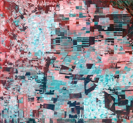
False-color composite aerial map outside Garden City, Kansas; Wired
Who says there's no contemporary art in the heartland? Wired magazine offers these images taken by NASA and USGS satellites, which capture crop and irrigation patterns across the rural international.
Betsy Mason explains, with larger, high-resolution images available by following the link:
The image above, taken by the USGS' Landsat 7 satellite on Sept. 25, 2000, is a false-color composite made using data from near infrared, red and green wavelengths and sharpened with a panchromatic sensor. The red areas actually represent the greenest vegetation. Bare soil or dead vegetation ranges from white to green or brown.
The image below is a simulated true-color shot from the same county in Kansas taken June 24, 2001 by NASA's Terra satellite. Bright greens are healthy, leafy crops such as corn; sorghum would be less mature at this time of year and probably a bit paler; wheat is ready for harvest and appears a bright gold; brown fields have been recently harvested. The circles are perfectly round and measure a mile or a half mile in diameter.

True-color imagery of Garden City, Kansas
As Wendell Berry asserts in Standing By Words, much of the arts now mirror commercial rhetoric, in that each forthcoming series of paintings, each new collection of songs or poems by a given artist must feature "new and improved" style - a misreading, Mr. Berry argues, of Ezra Pound's dictum "make it new."
It is interesting, then, to compare these images to the work of Damien Hirst, whose spot-paintings are currently on view worldwide, across all 11 Gagosian galleries.

Damien Hirst: The Complete Spot Paintings 1986 – 2011 (New York gallery); Mary Altaffer
Much is made of these works (Hirst's assistants actually "paint" these paintings) and their multi-million dollar auction prices, yet there's an irony in comparing these images - each geometric patterns that represent collaborative efforts aided by the latest precision technologies. The deeper irony, depending on which regions are captured in such satellite photography, is that the land illustrated within the frame is worth far more than Mr. Hirtst's spot paintings. Perhaps Gagosian should open up a gallery in Cedar Rapids.
Below we will offer a few more of these stunning aerial images. To further consider these connections, please visit the Rural American Contemporary Artists group and check out their current exhibit. Many thanks to Kelly Green for leading us to the article in Wired.
Pasture and logged acreage in Bolivia

The Al Khufrah Oasis irrigation project in Libya
Related Articles: